Cargando...
Recursos educativos
-
Nivel educativo
-
Competencias
-
Tipología
-
Idioma
-
Tipo de medio
-
Tipo de actividad
-
Destinatarios
-
Tipo de audiencia
-
Creador
-

Look after your skin
EduBook Organización
- 3978 visitas
The five senses Human beings have five senses: touch, sight, hearing, smell and taste. We use our senses to interact with the world around us. The sense organs Our sense of touch is in our skin. We use…
-

The five senses. Touch
EduBook Organización
- 3971 visitas
The five senses Human beings have five senses: touch, sight, hearing, smell and taste. We use our senses to interact with the world around us. The sense organs Our sense of touch is in our skin. We use…
-

Final Autoevaluation T12 03 - Waves. Light and sound
EduBook Organización
- 3525 visitas
Answer these questions: What do we use to see how white light is made up of many colours? Can a lunar eclipse happen if the sun is between Earth and the Moon? What is closer to the Earth in a solar…
-

Observe. The Earth from the air
EduBook Organización
- 3103 visitas
Look at the satellite image of the Earth and answer the questions: Which of the Earth’s continents appears the largest? Which oceans border the Earth’s continents? Which ocean borders the Spanish…
-

Unit 2: The representation of the Earth: maps
EduBook Organización
- 3008 visitas
Cartography (n): the process of making maps. conventional signs (n): symbols or colours used to represent the different elements on maps. coordinates (n): geographical coordinates are a system used to…
-
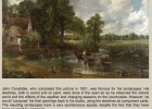
Painting: The Hay Wain, 1821
Tiching explorer Organización
- 1 lo usan
- 6277 visitas
This landscape by John Constable was inspired by the Suffolk countryside. Students may look at it for a minute and then describe as much as possible: colours, sky, composition, season, costumes,…
-

William Turner
Tiching explorer Organización
- 4286 visitas
This lesson outlines the biography of the Romantic painter William Turner. It features 3 examples of his works: "The Battle of Trafalgar", "The Fighting of the Temeraire", "Sun…
-

True/false. The stars and the Sun
EduBook Organización
- 2489 visitas
Are the following sentences true or false? The Sun rotates in an anticlockwise direction. The surface of the Sun is hotter than its interior. The diameter of the Sun is a hundred times that of the…
-

-

Think about it. Sexual reproduction in plants
EduBook Organización
- 2478 visitas
Remember what you have studied in this section and answer the questions: Why do more evolved plants have a smaller gametophyte? Discuss with a classmate. What is the advantage and disadvantage of having…


Te estamos redirigiendo a la ficha del libro...
