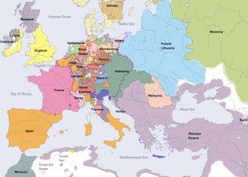
Euratlas Periodis Web - Map of Europe in Year 1600
Online historical atlas showing a map of Europe at the end of each century from year 1 to year 2000: Complete Map of Europe in Year 1600
-
Idioma:
- Inglés
-
Formato:
Interactivo
Recurso educativo
Cursos y asignaturas
Tipo de recurso
- Interactivo
- Ejercicio
Uso del recurso
- Clase
- Grupo reducido
- Individual
-
Aún no hay comentarios, ¡comparte tu opinión! Inicia sesión o Únete a Tiching para poder comentar


¿Dónde quieres compartirlo?
¿Quieres copiar el enlace?